With over 50 trails and many more proposed these trails are opening up all over the state including several upcoming trails in downstate New York.
The 750-mile Empire State Trail includes sections that are rail trails, but it is not exclusively a rail trail. The trail spans New York SRail Trails in New York have become very popular and an economic boost to many of the areas. tate from New York City to the Canadian border and from Albany to Buffalo, connecting various types of pathways including rail trails, canalway trails, and on-road sections. Rail trails, which are pathways converted from abandoned railway lines, form significant parts of this extensive trail network, especially along sections that follow historic canal routes and disused railways.
For the best information on rail trails in New York and other states, the Rails-to-trails Conservancy is a great resource.
These recreational trail systems not only help many New Yorkers with fitness and health getting them into the great outdoors but also aid many small towns financially by the increased tourists.
Here is a list of the Best Rail Trails in New York list by region:
New York Rail Trails Catskill Region
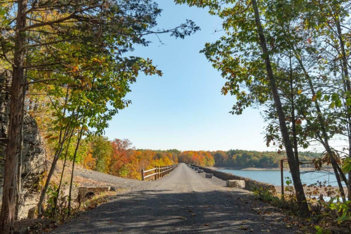
Catskill Scenic Trail

Catskill Scenic Trail
Catskill Scenic Rail Trail photo courtesy catskillscenictrail.org
Length: 26 miles
Trail use: Bicycle, hiking, running, cross-country skiing, horseback riding, and snowshoeing (all motorized vehicles are prohibited on this trail)
Surface: dirt, crushed stone, grass, and some pavement
This is my favorite trail in New York, and I’ve taken it many times and have done the whole trail. We usually park in the town of Stamford by the old train station then head either way.
This trail runs through Delaware County on the former Ulster & Delaware Railroad. Currently, a seasonal scenic railroad goes from the town of Arkville where there is a beautiful train station to Roxbury.
The rail trail begins in Roxbury and travels for 7 miles along the East Branch of the Delaware River and woods until you reach Grand Gorge. There it crosses the busy highway (Route 30). Caution must be taken in this area.
After that, the next 5 miles to Stamford is farmland with rolling hills in the background and a river near the trail. You should keep an eye out for beaver dams in this area of the trail.
The trail goes through the center of town where it crosses Main Street right by the restored train station. This area currently houses the information center and the Catskill Revitalization Corporation which runs the Catskill Scenic Trail and the Delaware and Ulster scenic railroad.
From Stamford, you travel 4 miles along the West Branch of the Delaware River through the town of Hobart. The part of the trail is the nicest as you are right along the side of the river. There are benches to stop and have a snack or even go fishing. If you want to go into the town of Hobart, you can do so by taking Maple Street to Main Street.
The remaining part of the trail goes through farms and woods and bridges that cross the river several times until you reach Bloomville and the former building of the Sheffield Farm Dairy plant, the country’s first milk pasteurization facility.
Parking
- The Trailhead on Route 10. north of Bloomville
- The Railroad Depot on Railroad Avenue, Stamford (large parking area)
- The intersection of Route 30 and Ferris Hill Road, just south of Grand Gorge
- Just north of Roxbury on Hardscrabble Road and Route 30
FIRE TOWERS
As a side note: Mount Utsayantha (3241 ft) is a mountain in the town of Stamford. You can drive to a typical New York-style fire tower at the top of the mountain. Just take Mountain Road (by car) for one mile. You can climb to the top of the fire tower for beautiful views of the area.
Ashokan Rail Trail

A newer rail trail in New York, the Ashokan Rail Trail also known as the ART, opened in fall 2019. It runs 11.5 miles along Route 28 from West Hurley to Boiceville. The trail offers stunning views of the Ashokan Reservoir.
There are plans to extend the trail 10 miles into Kingston. The mile markers on the trail currently begin at mile 10, already marked for future trail expansion.
This hard surface trail mainly hard crushed stone is made for biking, hiking, and running and is handicapped accessible. In winter the parking lots are plowed but the trail itself is not, but can be used for cross-country skiing and snowshoeing. Motorized vehicles are prohibited.
For the best views on this trailhead west towards the Boiceville parking area. In this direction, the views of the high peaks of the Catskill Mountains are just stunning. Also, this is where the trail is right next to the reservoir and you get to go over the Boiceville Bridge which crosses the Esopus Creek about 1,000 feet from the Boiceville parking area.
For more detailed information on this trail read my post, Ashokan Rail Trail.
Parking
- Just 6 miles west of the New York Thruway on Route 28 (watch for signs as it’s only a driveway on Route 28, you can’t see the parking lot) is the Woodstock Dike Parking Area. This is the biggest parking area with room for over 100 cars.
- Located right on Route 28 in Shokan, this parking lot gets very crowd
- Located on Route 28A (off of Route 28) in Boiceville
Finger Lakes Region Rail Trails
Jim Schug Trail also known as the Dryden Lake Park Trail

Length 4.2 miles
Surface: grass and gravel
This trail runs along the old Lehigh Valley Railroad from Main Street in Dryden Lake and passes and ends in the town of Harford and ends at the Finger Lakes Trail (hiking trail). There is an expansion planned for an additional 3.3 miles to the town of Freeville.
This trail starts by going through town and near some residential areas then crosses Route 38 towards rural farm fields and goes into wetlands. You go over several bridges and the trail is marked every ½ mile.
Around the lake area, you can see beautiful birds as this area is known for having some of the best birding in the Finger Lakes. Waterfowl birds are what you are looking for. Also, wildflowers are all around the lake area. Dryden Lake is also a popular place for ice fishing during the winter.
There are picnic tables, benches, and a fishing area by the lake. The lake is just stunning as I can still remember how nice this bike ride was and it’s been a few years since I’ve been there.
Keuka Outlet Trail

This 7-mile rail trail runs along the Keuka Lake Outlet, which is a stream and goes between Keuka Lake and Seneca Lake in the heart of the Finger Lakes. It connects the towns of Penn Yan and Dresden. Originally in an industrial area, there were numerous mills and hydropower dams used by lumber mills, tanneries, distilleries, and other mill products such as linseed oil, grain, and plaster. This waterway was used to transport these goods and at one point there were 27 locks in this 8-mile stretch of waterway. The canal required constant repair, so the state sold it to the Penn Yan and New York Railroad where it operated as a railroad until a hurricane destroyed it in 1972.
Today the area is mostly farms and vineyards but you can still see evidence of the old mills and dams. This narrow trail is hard dirt and crushed stone with a short section near Penn Yan that is paved. You can see waterfowl in this area along your ride. Almost in the center of the trail is Seneca Mills Falls, a beautiful waterfall with a picnic area and a great spot to take a break.
Parking
- From Main Street in Penn Yan turn west onto Elm Street to the community ballfield, the trail is behind the vendor booth and there is a parking lot.
- In Dresden take Route 54 East, after crossing Route 14 bear right on Seneca Street, the trailhead and the parking lot are on the right
Family Finger Lake Rail Trails
These are some family-oriented shorter rail trails in New York that are perfect for younger children.
Auburn-Fleming Trail in Auburn 3.2 miles road trip Auburn, NY
This is a flat trail that can be used for biking, hiking, or cross-country skiing. It’s a great trail through the woods and wetlands to take the family on. This scenic ride connected Route 34 in the town of Fleming to the town of Auburn by Dunning Ave.
Carlie Major Nature Trail 1.6-mile loop
This is a short trail with a lot of history as it was a train yard. There are 3 railroad bridges, several dams, ruins of millwork buildings, and a pretty creek. It’s easy and fast and handicap accessible.
You can access the trail on Crow Hill Road in Montville and Mill Road just north of Old Seneca Turnpike.
Hudson Valley Rail Trails in New York
Wallkill Valley Rail Trail

Once the Wallkill Valley Railroad, today it’s a 22.5-mile outdoor recreation treasure in Ulster County with many access points, going from the towns of Gardiner through New Paltz, Rosendale, Ulster to Kingston city line. The rail trail is made of crushed stone and is used for walking, jogging, biking, horseback riding, cross-country skiing, and snowshoeing. Leashed dogs are allowed.
The highlight of this trail is the Rosendale trestle which is 150 feet high and 940 feet long towering over the Rondout Creek. There are also other places of interest along the trail including several bridges, streams, the Wallkill River, farmland, hilly, apple orchards, and views of the mountains.
There are caves with exceptional cold air coming out of them that surprise you as you pass them but feel great on a hot day. You also see remnants of cement mining that was once done in the area.
This trail goes through the town of New Paltz which is a college town with a hippie vibe. The old train station is a restaurant and there are many restaurants, bars, ice cream, and places to shop in town. There are even bike racks throughout the town for your convenience.
Parking
Access and parking for the trail are in Gardiner, Sojourner Park in New Paltz, Binnewater Road in Rosendale, and Rockwell Lane in Kingston. Click here for a printable map of the trail and parking.
Heritage Trail

This 11.5-mile trail is great for families as it’s mostly paved (9-mile section) and has few street crossings.
Starts in Monroe at Crane Park, also known as Airport Park, make sure you take a look at the old Saber fighter jet in the corner. The trail travels through farmland and woods between Chester and Goshen.
The trail goes through the Village of Chester where the restored train station is now the Chester Depot Museum.
Follow the signs in Goshen where you will pass the police station which was once the old railroad depot. Follow Railroad Avenue to where the trail becomes dirt.
This part of the trail is quiet with no development. Birding and horseback riding are popular in this section.
The trail ends at Harley Road but there are plans to extend it towards Middletown.
Parking
Airplane Park on Route 208 in Monroe
Goshen Trailhead—Take exit 3 off Interstate 84 to State Route 17M to Harley Street. The trail is on the left. Parking is limited at this location.
Harlem Valley Rail Trail
The Harlem Valley Rail Trail offers a scenic and tranquil escape through the heart of Dutchess and Columbia Counties in upstate New York. This paved trail is built on the abandoned New York and Harlem Railroad line, showcasing the natural beauty and historical richness of the area.
As of the latest updates, the trail consists of several completed sections totaling over 20 miles, with plans to extend it.
Adirondack Rail Trails in New York
Terry Gordon Trail

Along Lake Champlain, this short (1.6 miles) paved path follows the Canadian Pacific Railway which is still active today. The views of the lake are stunning along with Vermont’s Green Mountains in the background this trail also has a military history. It is the former home to the Plattsburgh Air Force Base as well as the US Armed Forces Barracks where Ulysses S. Grant once lived.
The trail also connects to the lake and a fishing pier. At the end of the trail, you can either turn around or connect with other bike trails in the area.
You can reach the trail off Route 9 on Hamilton Street. There isn’t a designated parking area for the trail but there is street parking by the trailhead.
Warren County Bikeway

Located in the southern Adirondacks, this trail Begins in Glen Falls and travels 10 miles to Lake George Beach State Park in the Village of Lake George. This paved surface once was the Delaware and Hudson Railway bringing passengers from New York City to the resorts in Lake George. Some tracks remain, and you can see them at the beginning of the trail by Platt Street.
The trail passes through residential areas with some industrial. You will pass Coopers Cave Ale Company where you can stop for ice cream or a soda. There are bike racks and picnic tables for your convenience. You will know as you approach Queensbury trees will appear and you will cross Quaker Road and Halfway Brook Bridge. Here there is another opportunity for ice cream before you go into the woods.
At mile 3.3 you will be detoured from the trail and go on the road passing large homes. Before you know it, you will be back on the trail crossing over a bridge on Glen Lake. Enjoy your views of the lake as you paddle. At this point, you will be on the Old Hudson Valley Railway right of way where they run trolleys.
At mile 8 you are almost done with your journey; you will be riding parallel to Route 9 where you can see the Uncle Sam statue in the Magic Forest theme park. It’s downhill from here until you reach the end at the shore of Lake George. It’s time to get off the bike and take a dip in the cooler waters of Lake George!
Tupper Lake/Lake Placid
The Tupper Lake Lake Placid rail trail, also known as the Adirondack Rail Trail, is a recreational trail that runs between Tupper Lake and Lake Placid in New York. The trail follows the path of a former railroad line, offering a scenic and accessible route through the Adirondack Mountains. Here are some key aspects of the trail:
- Length and Surface: The trail is planned to be about 34 miles long. It is a multi-use trail designed for activities such as hiking, biking, and snowmobiling, depending on the season. The surface is generally smooth, making it accessible for bicycles and pedestrians.
- Scenery and Attractions: As it winds through the Adirondacks, the trail offers stunning views of mountains, forests, and wildlife. It passes through several small towns and provides access to natural attractions, including lakes and rivers.
- Accessibility and Use: The trail is designed to be accessible year-round, with different activities highlighted according to the season. In winter, it can be used for snowmobiling and cross-country skiing, while summer months are perfect for hiking and biking.
- Development and Status: The trail has been a subject of extensive planning and development. Efforts to convert the old railroad into a trail have involved local communities and state authorities to enhance recreational opportunities and boost local economies.
- Connections and Extensions: The trail connects several communities and serves as a link between various points of interest in the region. It also complements other trails in the Adirondack Park, providing options for extended exploration.
This trail is part of a broader movement to repurpose old rail lines into recreational trails, providing economic, environmental, and health benefits to the regions they traverse.
Long Island Region
North Shore Rail Trail
The North Shore Rail Trail in Long Island, New York, is a 10-mile paved trail that runs parallel to Route 25A, from Mount Sinai to Wading River. It follows the path of the former Long Island Rail Road’s North Shore Branch.
The trail is fully paved and provides a safe and scenic route for pedestrians, cyclists, and inline skaters. It’s particularly popular among local residents for recreational activities like walking, jogging, and biking.
The North Shore Rail Trail offers a mix of scenic views, passing through residential areas, woodlands, and near local parks and beaches. The trail provides a great opportunity to enjoy the natural beauty of Long Island’s north shore.
Rochester/Buffalo Rail Trails in New York
Clarence Pathways

Four trails make up the Clarence Pathways in Erie County. Here is a brief description of each trail. You can take all four for a day of biking or just take one for a short ride.
West Shore Trail 3.5 miles
This trail follows the West Shore and Buffalo Railroad through rural Clarence and goes through local parks, residential areas, and downtown. In the town, the trail goes on some sidewalks then the trail resumes. Here the trail turns into the Newstead Bike Path.
Newstead Bike Path 4.8 miles
You ride 2.5 miles through farmland and woods until you reach the Akron Junction where the trail splits. The Newstead trail continues north to the town of Akron. Or you can take the Peanut Lane Trail.
Peanut Lane Trail 2.3 miles
Follows the New York Center Railroad and is called the Peanut Line due to its short distance. Going through farmland towns in the town of East Amherst, the trail emerges into the Clarence Bike Trail.
Clarence Bike Trail 6.1 miles
The trail heads west on the old rail line through farmland then through the residential area through Clarence until its end.
Genesee Riverway Trail

Length: 22.8 miles
Surface: Paved and concrete
Usage: Biking, walking, inline skating, and cross-country skiing. This trail is wheelchair accessible.
Although the trail is known for its stunning waterfalls you should start at the Ontario Beach Park where you can see views of Lake Ontario from the pier. Then take a look and ride if open at the Carousel which has been operational since 1905. Continue the trail to the Genesee River and towards Turning Point Park where you go over the river on a winding boardwalk. After this, you will see railroad tracks used for freight trains.
Then you will be on sidewalks and a bike lane for a short time until the trial resumes, here you can go to the Seneca Park Zoo. Continue to the river again and come to Maplewood Park where there are restrooms.
Now you are up to the part of the trail where the waterfalls begin. You can view the first waterfall at Lowes Falls Park. You will cross a hydroelectric dam and another falls. Shortly after you can get a glimpse at the city of Rochester. You will then come to the tallest falls, High Falls, which is 96 feet high. The trail will divide, and the eastern part ends at the Erie Canalway Trail. The western side continues to the Genesee Valley Greenway near Rochester International Airport.
Parking
Northern End—Ontario Beach Parking lots. Start the trail at the pier in the northeast corner.
Southern End—In the Genesee Valley Park near Moore Road and the Eric Canal. The park is on the left.
Capital Region Rail Trails New York
Helderberg-Hudson Rail Trail

This trail travels the old Delaware and Hudson Railway. Most other this 9-mile paved trail goes through residential areas of the suburbs of Albany but offers views of bridges, creeks, and woodlands. You can even see wild animals such as deer, turkey, and bald eagles while riding. Part of the trail is not far from the Hudson River to take in the views.
After 2 miles you get to the Bethlehem Veterans Memorial Park where you can rest on the many benches. The trail passes by the center of Delmar where there are services such as restaurants and shopping.
There is artwork throughout the trail done by local artists. Enjoy these murals along the way to the end.
Parking
Voorheesville Trailhead—At the end of Grove Street near the train tracks. The parking lot and the Rail Trail Pavilion is on the right.
Albany Trailhead—Off Interstate 787 at exit 2, go to Green Street, Parking lot is just south of the intersection of Old Pearl Street and Kenwood Road.
Zim Smith Trail

This 12-mile, mostly paved trail goes from Ballston Spa through Malta, Round Lake Village, Clifton Park, Halfmoon, and Mechanicville. Mostly used for biking and walking and is also for strollers and wheelchair accessible.
The trail runs through Malta’s Shenantaha Creek Park where there are picnic tables, a playground for the kids, tennis courts, volleyball, and restrooms. The trail is mostly wooded and runs by the backyards of homes.
Then you pass under the thruway Adirondack Northway to the Village of Round Lake. Here you come to a favorite on the trail at Leah’s Cakery. A must-stop for the best cakes, buns, cookies, and other goodies at affordable prices. You won’t regret it. From here you cross Route 9 to the towns of Clifton Park and Halfmoon.
In 2020, the trail was extended to the city of Mechanicville. There are plans to extend it further into Saratoga Springs.
It follows the old railroad of Rensselaer and Saratoga Railroad which became the Delaware and Hudson Railroad in 1945.
Parking
Ballston Spa Trailhead—Parking is at the end of Oak Street in Ballston Spa.
Coons Crossing Trailhead—Off exit 10 of Interstate 87, parking is on both the right and left sides of Cary Road/Coons Crossing Road.

I love the information you provided about the trails near Finger Lakes. If it weren’t for Covid, we would have gone there this past summer. It is such a beautiful region, especially in the summer. I’m bookmarking this post for future reference.
The Finger Lakes are beautiful both for biking and hiking. There are also lots of wineries and breweries there too. I hope you are able to get there this summer and explore the beauty of the Finger Lakes. We are planning to go there in July, hopefully, we can.
Wow, so many beautiful trails are there in New York..I visited New York but didn’t go for any trails, your blog looks beautifully explained the all trails. Thanks for writing down.
Most people that visit NY visit New York City. Upstate New York has beautiful trails all over for biking, hiking and so much more.
This is a great list! My husband and I have been talking about doing a big US road trip down the road someday when the travel restrictions are lifted, so I’m going to save this to help with planning that. We’re both HUGE outdoor travel lovers, so the idea of checking out new trails all over is high on our list of fun things to do.
We also love the outdoors and finding new trails can be a lot of fun, happy planning!