The Ashokan Rail Trail, as known as ART, is New York’s newest rail-trail which opened in the fall of 2019. This 11.5-mile trail parallels the Ashokan Reservoir.
The hard crushed stone surface is made for biking, hiking, walking and running and is wheelchair accessible.
In winter the parking areas are plowed however the trail is not but can be used for cross-country skiing and snowshoeing.
Note: This trail is for non-motorized uses as all ATV and snowmobiles are prohibited.
The Trail

This is one beautiful well-maintained trail that is approximately 10 to 12 feet wide giving you plenty of room to go around others or travel with people using the trail in both directions.
The trail runs on the abandoned Ulster & Delaware Railroad and is opened from sunrise to sunset throughout the year. I should also mention that leashed dogs are allowed on the trail.
We went for our bike ride early in the morning around 9 am and found the trail enjoyable as it wasn’t too crowded. When we were leaving it started to get crowded.
We didn’t ride the whole trail but where we did, it was mostly shaded with woods on each side. You can get a view of the reservoir at the beginning of the trail near the Woodstock Dike parking.
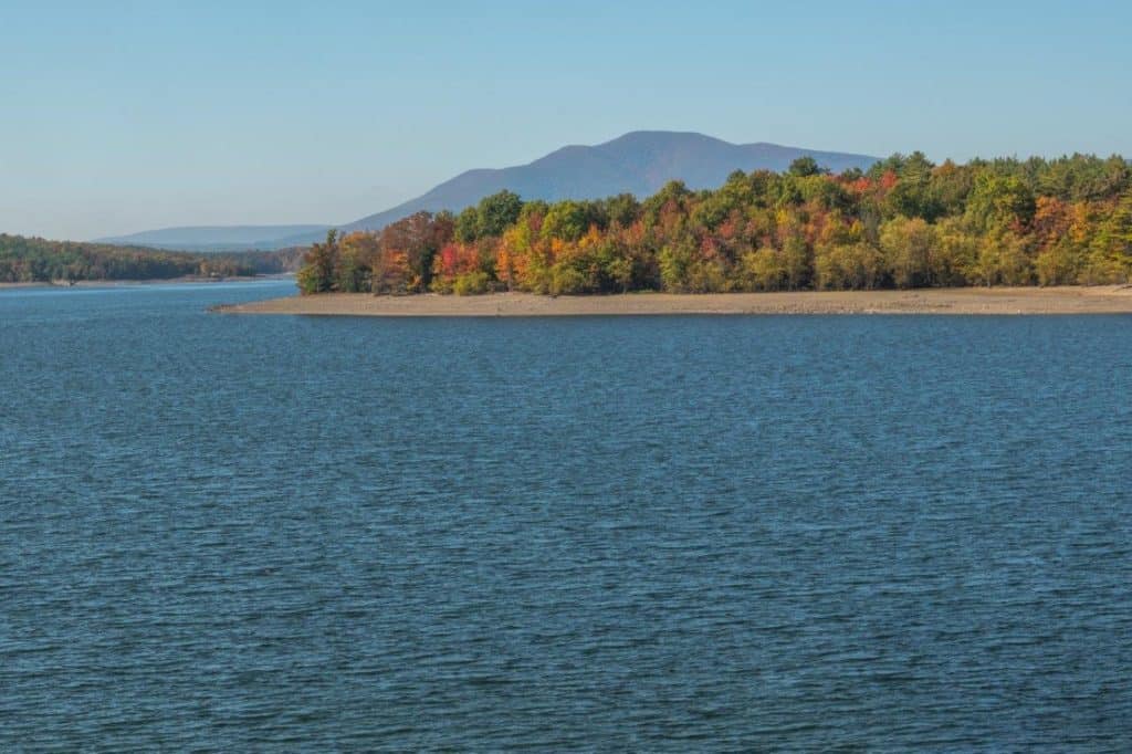
For best views on this trailhead go west towards the Boiceville parking area. In this direction, the views of the high peaks of the Catskill Mountains are just stunning. Also, this is where the trail is right next to the reservoir and you get to go over the Boiceville Bridge which crosses the Esopus Creek about 1,000 feet from the Boiceville parking area.
Related Article: Incredible Short Hikes in Upstate New York

Ashokan Rail Trail Parking Areas
Woodstock Dike Trailhead
This trailhead is the furthest east and is closest to the New York State Thruway at exit 19 (6 miles away). Its entrance is located on Route 28 in West Hurley however you can’t see the parking area from the road so watch for the signs.

This is the biggest parking lot with a capacity of around 100 vehicles. When we stopped there, a person from the DEP was in the parking area to answer any questions but this was on a weekend so I’m not sure if someone would be there during the week.
Ashokan Station Trailhead
Located right on Route 28 in Shokan, this parking area can get crowded. From here you can access the trail in either direction, east towards Woodstock and west towards Boiceville.
In this area, the trail is away from the reservoir and you are riding with woods on either side. We went in spring and the trail was shaded making for a pleasant ride.
Boiceville Bridge Trailhead

Located on Route 28A (off Route 28) in Boiceville, this is the most western trailhead. The parking area is smaller than the others. This is the most scenic part of the trail.
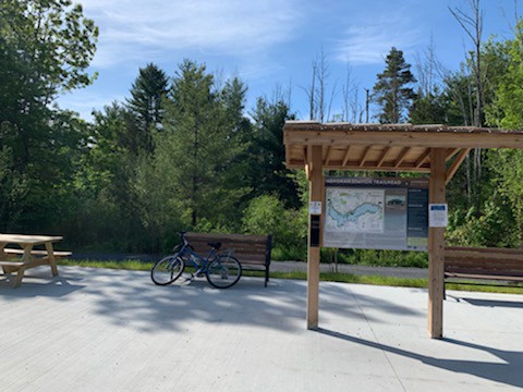
In each of the parking areas, there are restrooms (portable) for your convenience. There are also benches and picnic tables to relax and a map of the entire trail.
Ashokan Reservoir
New York City gets its drinking water from 12 reservoirs and 3 lakes. These are broken down into sections of which the Catskill Aqueduct supplies 40% of the drinking water for New York City.
The Ashokan Reservoir is part of the Catskill Aqueduct along with the Schoharie Reservoir and the Shandaken Tunnel. When full, this 11.8-mile long reservoir can hold up to 122.9 billion gallons of water. It’s the deepest reservoir that New York City owns at 180 feet at its deepest point.
Fishing is a big hobby along the reservoir however you will need a watershed access permit issued by the NYC DEP. These permits can be obtained through their website at the NYC Recreation-DEP.
A permit IS NOT needed when using the rail-trail.
There are over 15 species of fish in the Ashokan (meaning “Place of Fish”) Reservoir with the brown trout being the most common. Every spring more than 16,000 brown trout are released into the reservoir. Rowboat can be used however they need to be stream-cleaned before accessing the reservoir.
A great fishing spot is where the reservoir meets the Esopus Creek. The best techniques for catching these fish are with fresh bait as well as trolling with plugs or spoons.
Note: A New York Fresh Water Fishing License is required to fish in any reservoir or any other body of water in New York State. For more information on these licenses and regulations visit this website.
Rail Trail Map

There is a trail map at each of the parking areas for your reference. A brochure can also be obtained and are usually located at each trailhead except right now because of COVID they are not being handed out.
The trail is marked with a permanent marker every .5 miles. The east part of the trail (Woodstock Dike markers begin at mile-marker 10 and continue towards the west for 11.5 miles (mile-marker 21.5).
There is hope that one day this rail trail will be extended east to Kingston, NY. This is the reason why the trail starts at mile 10.
For your safety when bicycling on this trail on any other trail always wear a helmet.
Enjoy Your Ride
Although the Ashokan Rail Trail doesn’t go through any towns as some rail-trails do, you will love your ride or walk on this trail. The scenery is stunning and there is a peacefulness that surrounds you when you’re riding along the reservoir.
Kathy xoxo
Related Articles:
5 Catskill Park Fire Tower Hikes
Pennsylvania’s Pine Creek Rail Trail
Pin for Later
